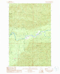
1990 Map of Spruce Mountain
USGS Topo · Published 1990About this map
The Hoh River winds through this temperate landscape, serving as a primary corridor for travel and settlement in the late twentieth century. Land use is sharply divided by the boundaries of Olympic National Park to the north and the Olympic National Forest to the south. The presence of the Huelsdonk Ranch, its associated Huelsdonk Ridge, and a nearby Cem reflect the endurance of early homesteading families in this isolated valley. Cultural markers like the Lewis Ranch and Morgans Crossing Campsite indicate a transition toward recreational land use alongside traditional ranching. The terrain is defined by steep ridges and numerous drainage systems, including Fraker Creek, Tumwater Creek, and Owl Creek. Access is largely limited to unpaved 4wd tracks, highlighting the rugged nature of the region's interior before more modern infrastructure arrived.
Find a feature on this map
40 named features on this map. Tap any name to fly to it.
Don’t see what you’re looking for? This feature index may not catch every label — zoom into the map to look around manually.
Map Details
Editions of this 1990 Spruce Mountain Map
This is the sole edition of this map. No revisions or reprints were ever made.
Other maps of this area

1939 · Mount Tom
USGS Topo · 1:62,500

1943 · Spruce Mountain
USGS Topo · 1:62,500

1943 · Copalis Beach
USGS Topo · 1:250,000

1950 · Slide Peak
USGS Topo · 1:24,000

1951 · Copalis Beach
USGS Topo · 1:250,000

1956 · Kloochman Rock
USGS Topo · 1:62,500

1956 · Mount Tom
USGS Topo · 1:62,500

1956 · Spruce Mtn.
USGS Topo · 1:62,500

1956 · Salmon River
USGS Topo · 1:62,500
1957 · Mount Tom
USGS Topo · 1:62,500