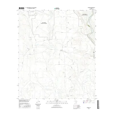
2016 Map of Spurger
USGS Topo · Published 2016About this map
The settlement of Spurger serves as the central hub of this East Texas landscape, positioned just west of the Neches River where the boundary between Jasper Co and Tyler Co follows the river's winding course. Much of the northern terrain is dedicated to the Big Thicket National Preserve, a protected area of dense woodlands and wetlands characterized by an intricate drainage system including Beech Cr, Mill Cr, and Little Beech Cr. A network of rural routes like FM 1013 and the Big Thicket Trl connect the residential clearings to the surrounding timberlands. The mapping of Turner Br and various country roads illustrates the persistent rural character of this region, where forestry and conservation efforts define the modern land use patterns alongside long-established residential pockets.
Find a feature on this map
52 named features on this map. Tap any name to fly to it.
Don’t see what you’re looking for? This feature index may not catch every label — zoom into the map to look around manually.
Map Details
Editions of this 2016 Spurger Map
This is the sole edition of this map. No revisions or reprints were ever made.
Other maps of this area

1954 · Beaumont
USGS Topo · 1:250,000

1955 · Woodville
USGS Topo · 1:62,500

1955 · Curtis
USGS Topo · 1:62,500

1957 · Beaumont
USGS Topo · 1:250,000

1958 · Warren
USGS Topo · 1:62,500

1958 · Spurger
USGS Topo · 1:62,500

1984 · Beaumont
USGS Topo · 1:250,000

1984 · Potato Patch Lake
USGS Topo · 1:24,000
1984 · Beech Grove
USGS Topo · 1:24,000
1984 · Town Bluff
USGS Topo · 1:24,000