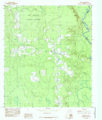
1984 Map of Spurger
USGS Topo · Published 1985About this map
Big Thicket National Preserve dominates this section of East Texas, where the dense piney woods meet the winding course of the Neches River. The landscape is a mosaic of conservation land and small-scale resource extraction, notably marked by a Gravel Pit and an Oil Well that hint at the local economy during the late 1970s and early 1980s. The settlement of Spurger serves as the primary hub, situated near the Spurger Lookout Tower, a vital landmark for forest monitoring in this heavily timbered region. To the north, the small community of Oldham sits near the confluence of Beech Creek and smaller tributaries like Mill Creek. The eastern boundary is defined by the river’s oxbows and the Tyler Co Jasper Co line, featuring riparian landmarks such as Round Lake and the drainage of Turner Branch.
Find a feature on this map
12 named features on this map. Tap any name to fly to it.
Don’t see what you’re looking for? This feature index may not catch every label — zoom into the map to look around manually.
Map Details
Editions of this 1984 Spurger Map
This is the sole edition of this map. No revisions or reprints were ever made.
Other maps of this area

1954 · Beaumont
USGS Topo · 1:250,000

1955 · Woodville
USGS Topo · 1:62,500

1955 · Curtis
USGS Topo · 1:62,500

1957 · Beaumont
USGS Topo · 1:250,000

1958 · Warren
USGS Topo · 1:62,500

1958 · Spurger
USGS Topo · 1:62,500

1984 · Beaumont
USGS Topo · 1:250,000

1984 · Potato Patch Lake
USGS Topo · 1:24,000
1984 · Beech Grove
USGS Topo · 1:24,000
1984 · Town Bluff
USGS Topo · 1:24,000