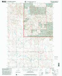
1998 Map of Square Top Butte
USGS Topo · Published 2001About this map
The Grand River National Grassland dominates this corner of Perkins County, where the high plains terrain is defined by prominent topographical landmarks and an intricate network of seasonal drainages. Two major elevations, Square Top Butte and Scotch Cap Butte, rise above the surrounding prairie, serving as natural navigational markers for generations of ranchers and travelers. The hydrological pattern is shaped by the Grand River, which draws from tributaries including Snake Creek, Timber Creek, and Spring Creek. Human presence in the late twentieth century is evidenced by scattered Windmill and Well sites essential for livestock, while the Bison Country Club and Thunder Butte Creek drainage highlight the local intersection of social recreation and the natural landscape. The township boundaries of Cash and Marshfield provide a framework for these wide-open reaches of western South Dakota.
Find a feature on this map
16 named features on this map. Tap any name to fly to it.
Don’t see what you’re looking for? This feature index may not catch every label — zoom into the map to look around manually.
Map Details
Editions of this 1998 Square Top Butte Map
This is the sole edition of this map. No revisions or reprints were ever made.
Other maps of this area

1954 · Lemmon
USGS Topo · 1:250,000

1957 · Lemmon
USGS Topo · 1:250,000

1983 · Grandmas Butte
USGS Topo · 1:24,000

1983 · Square Top Butte
USGS Topo · 1:24,000

1983 · Bison
USGS Topo · 1:24,000

1983 · Cole Dam
USGS Topo · 1:24,000

1983 · Date NE
USGS Topo · 1:24,000

1983 · Little Nasty Creek
USGS Topo · 1:24,000

1983 · Daviston
USGS Topo · 1:24,000

1983 · Owen Lake
USGS Topo · 1:24,000