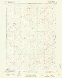
1952 Map of Squaw Butte
USGS Topo · Published 1976About this map
Squaw Butte dominates the central portion of this mid-century landscape in Fremont County, Wyoming, standing as a prominent landmark for travelers and ranchers. The terrain is characterized by the winding path of Muskrat Creek and the distinctive geological formation of the Chalk Hills to the southeast. These features define a high-desert environment where water management was essential for survival and livestock.
Find a feature on this map
9 named features on this map. Tap any name to fly to it.
Don’t see what you’re looking for? This feature index may not catch every label — zoom into the map to look around manually.
Map Details
Editions of this 1952 Squaw Butte Map
2 editions found
Other maps of this area

1952 · Seventy-one Reservoir
USGS Topo · 1:24,000

1952 · Squaw Butte NE
USGS Topo · 1:24,000

1952 · Squaw Butte
USGS Topo · 1:24,000

1952 · Ocla Draw
USGS Topo · 1:24,000

1952 · Moneta
USGS Topo · 1:24,000

1952 · Double Butte
USGS Topo · 1:24,000

1952 · Haybarn Hill
USGS Topo · 1:24,000

1952 · Love Ranch
USGS Topo · 1:24,000

1952 · Butte Well
USGS Topo · 1:24,000

1955 · Arminto
USGS Topo · 1:250,000