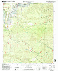
1999 Map of Squirrel Springs Canyon
USGS Topo · Published 2002About this map
The Tularosa River flows through the northern reaches of this high-altitude landscape, where the Apache National Forest meets the Gila National Forest. This 1999 revision captures a network of canyon systems and livestock watering infrastructure, including numerous named tanks like Bear Tank and Govina Canyon Tank No 8. The map documents the intricate drainage patterns of Govina Canyon, Squirrel Springs Canyon, and Five Springs Canyon, which descend from prominent heights such as Wagontongue Mountain. The presence of several named water sources, such as Upper Cold Spring and Squirrel Spring, highlights the critical importance of reliable water in this arid environment. Surveyed boundaries for the Quemado Ranger District and Reserve Ranger District provide administrative context for the public lands, while scattered 4wd routes indicate the primitive access across the canyon floors and ridges.
Find a feature on this map
50 named features on this map. Tap any name to fly to it.
Don’t see what you’re looking for? This feature index may not catch every label — zoom into the map to look around manually.
Map Details
Editions of this 1999 Squirrel Springs Canyon Map
This is the sole edition of this map. No revisions or reprints were ever made.
Other maps of this area

1915 · Reserve
USGS Topo · 1:125,000

1918 · Pelona
USGS Topo · 1:125,000

1918 · Reserve
USGS Topo · 1:125,000

1954 · Clifton
USGS Topo · 1:250,000

1957 · Clifton
USGS Topo · 1:250,000

1958 · Clifton
USGS Topo · 1:250,000

1962 · Clifton
USGS Topo · 1:250,000
1965 · Milligan Mountain
USGS Topo · 1:24,000
1965 · Aragon
USGS Topo · 1:24,000
1965 · Eagle Peak
USGS Topo · 1:24,000