1954 Map of St. Charles
USGS Topo · Published 1975About this map
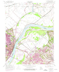
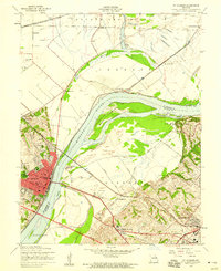
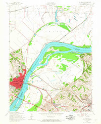
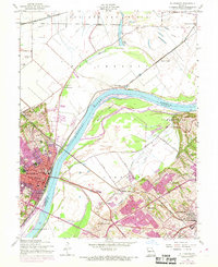
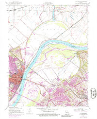
The Missouri River serves as the central artery on this map, dividing St Charles from the expanding suburbs of Bridgeton and Robertson. This 1974 photorevision highlights a period of significant growth, with new residential developments and the Mark Twain Expressway altering the landscape. Institutional history is prominent in the city of St. Charles, featuring Lindenwood College, Sacred Heart Academy, and Immanuel Sch. North of the city, the land transitions to the floodplains of Portage Des Sioux, where the Burlington Northern railroad cuts through the flats near Blase and Boschertown. The presence of the Levee and large river features like Bryan Island underscore the ongoing effort to manage the river’s path against the encroaching urban sprawl.
Find a feature on this map
46 named features on this map. Tap any name to fly to it.
Don’t see what you’re looking for? This feature index may not catch every label — zoom into the map to look around manually.
Map Details
Editions of this 1954 St. Charles Map
5 editions found
Other maps of this area

1903 · O'Fallon
USGS Topo · 1:125,000

1924 · Robertson
USGS Topo · 1:24,000

1927 · St. Charles
USGS Topo · 1:62,500

1931 · Brussels
USGS Topo · 1:62,500

1932 · Manchester NE
USGS Topo · 1:24,000

1933 · Creve Coeur
USGS Topo · 1:24,000

1933 · Clayton
USGS Topo · 1:24,000

1933 · Saint Charles
USGS Topo · 1:62,500

1935 · Florissant
USGS Topo · 1:24,000

1939 · Brussels
USGS Topo · 1:62,500