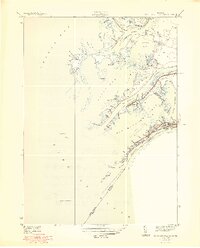
1949 Map of St. Clair Flats
USGS Topo · Published 1949About this map
Harsens Island and the intricate labyrinth of the St. Clair River delta dominate this 1937 survey. The landscape is defined by a dense network of narrow waterways and cuts, such as Chenal Ecarte and Broad Cut, which separate numerous marshy islands and peninsulas before they open into Lake St. Clair. Along the South Channel, the settlement of Riverside and several prominent social hubs like the Old Club and St Clair Flats Club indicate the area's development as a premier maritime recreational destination. The map illustrates the complex international boundary where St Clair Co meets Ontario, tracing the United States Canada line through the deep water of the South Channel. Notable landforms like Dickinson Island and the long sweep of Muscamoot Ridge show the fragile, shifting geography of this freshwater delta.
Find a feature on this map
79 named features on this map. Tap any name to fly to it.
Don’t see what you’re looking for? This feature index may not catch every label — zoom into the map to look around manually.
Map Details
Editions of this 1949 St. Clair Flats Map
2 editions found

Other maps of this area

1905 · Grosse Pointe
USGS Topo · 1:62,500

1912 · Mt Clemens
USGS Topo · 1:62,500

1914 · Algonac
USGS Topo · 1:62,500

1918 · Grosse Pointe
USGS Topo · 1:62,500

1929 · Mt Clemens
USGS Topo · 1:62,500

1936 · New Haven
USGS Topo · 1:31,680

1936 · Selfridge Field
USGS Topo · 1:31,680

1936 · New Baltimore
USGS Topo · 1:31,680

1936 · Algonac
USGS Topo · 1:31,680

1939 · New Baltimore
USGS Topo · 1:24,000