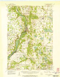
1955 Map of St. Croix Dalles
USGS Topo · Published 1957About this map
The St. Croix River carves a deep valley through this mid-century landscape, defining the border between Wisconsin and Minnesota. This 1955 survey documents a period of strategic military and civil development, anchored by the Osceola Air Force Station and the Osceola Landing Field. The rugged dalles of the river are highlighted by Lake O' the Dalles, while the regional rail economy is dictated by the Minneapolis St Paul and Sault Ste Marie line.
Find a feature on this map
92 named features on this map. Tap any name to fly to it.
Don’t see what you’re looking for? This feature index may not catch every label — zoom into the map to look around manually.
Map Details
Editions of this 1955 St. Croix Dalles Map
4 editions found

Other maps of this area

1900 · St Croix Dalles
USGS Topo · 1:62,500

1901 · St Croix Dalles
USGS Topo · 1:62,500

1948 · New Richmond
USGS Topo · 1:62,500

1948 · Stillwater
USGS Topo · 1:62,500

1949 · New Richmond
USGS Topo · 1:62,500

1949 · Stillwater
USGS Topo · 1:62,500

1950 · Rush City
USGS Topo · 1:48,000

1950 · Deer Park
USGS Topo · 1:62,500

1950 · Balsam Lake
USGS Topo · 1:62,500

1951 · Milltown
USGS Topo · 1:48,000