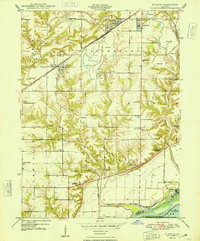
1948 Map of St. David
USGS Topo · Published 1948About this map
Industrial excavations define the northern uplands of this Fulton County landscape, where numerous Strip Mine operations flank the settlements of St David and Dunfermline. The Chicago Burlington and Quincy railroad serves as the primary corridor for moving resources through the townships of Putnam and Buckheart. To the south, the topography shifts toward the Illinois River floodplain, protected by an extensive Levee system. This area preserves a dense network of early 20th-century rural infrastructure, including more than a dozen local schools such as Science Hill Sch, Morning Star Sch, and Bordner Sch. The map also captures the Chautauqua National Migratory Waterfowl Refuge and Lake Chautauqua along the river's edge, alongside the archaeological significance of the Tampico Mounds near Little America.
Find a feature on this map
44 named features on this map. Tap any name to fly to it.
Don’t see what you’re looking for? This feature index may not catch every label — zoom into the map to look around manually.
Map Details
Editions of this 1948 St. David Map
2 editions found

Other maps of this area

1912 · Canton
USGS Topo · 1:62,500

1925 · Havana
USGS Topo · 1:62,500

1929 · Manito
USGS Topo · 1:62,500

1930 · Glasford
USGS Topo · 1:62,500

1932 · Manito
USGS Topo · 1:62,500

1947 · Lewistown
USGS Topo · 1:24,000

1947 · St. David
USGS Topo · 1:24,000

1947 · Havana
USGS Topo · 1:24,000

1948 · Duncan Mills
USGS Topo · 1:24,000

1948 · Lewistown
USGS Topo · 1:24,000