
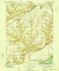
1948 Map of St. David
USGS Topo · Published 1948About this map
Industrial activity and rural education define this landscape just west of the Illinois River in the late 1940s. Large-scale Strip Mine operations dominate the northern townships of Putman and Buckheart, carving into the terrain around St David and Dunfermline. This heavy extraction industry exists alongside a dense network of one-room schoolhouses, including Morning Star Sch, Science Hill Sch, and Elm Tree Sch, which served the farming families of Liverpool and Lewistown townships.
Find a feature on this map
44 named features on this map. Tap any name to fly to it.
Don’t see what you’re looking for? This feature index may not catch every label — zoom into the map to look around manually.
Map Details
Editions of this 1948 St. David Map
2 editions found
Other maps of this area

1912 · Canton
USGS Topo · 1:62,500

1925 · Havana
USGS Topo · 1:62,500

1929 · Manito
USGS Topo · 1:62,500

1930 · Glasford
USGS Topo · 1:62,500

1932 · Manito
USGS Topo · 1:62,500

1947 · Lewistown
USGS Topo · 1:24,000

1947 · St. David
USGS Topo · 1:24,000

1947 · Havana
USGS Topo · 1:24,000

1948 · Duncan Mills
USGS Topo · 1:24,000

1948 · Lewistown
USGS Topo · 1:24,000