
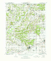
1941 Map of St. Elmo
USGS Topo · Published 1958About this map
Saint Elmo and Altamont anchor a landscape defined by the intersection of major rail lines and rural industry during the early 1940s. The region is heavily influenced by the presence of the Carter Refinery, which appears twice as a primary landmark, suggesting a burgeoning petroleum economy alongside traditional agriculture. A dense network of one-room schools, such as Martin Box Sch, Pleasant Plains Sch, and Prairie Cottage Sch, provides a detailed look at the local educational geography before the era of school consolidation.
Find a feature on this map
97 named features on this map. Tap any name to fly to it.
Don’t see what you’re looking for? This feature index may not catch every label — zoom into the map to look around manually.
Map Details
Editions of this 1941 St. Elmo Map
2 editions found
Other maps of this area

1942 · Shelbyville
USGS Topo · 1:62,500

1944 · Ramsey
USGS Topo · 1:62,500

1945 · St. Elmo
USGS Topo · 1:62,500

1945 · Kinmundy
USGS Topo · 1:62,500

1945 · Vandalia
USGS Topo · 1:62,500

1946 · Shelbyville
USGS Topo · 1:62,500

1946 · Ramsey
USGS Topo · 1:62,500

1947 · Vandalia
USGS Topo · 1:62,500

1947 · Kinmundy
USGS Topo · 1:62,500

1947 · Pana
USGS Topo · 1:62,500