
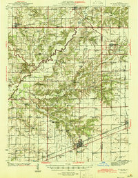
1945 Map of St. Elmo
USGS Topo · Published 1945About this map
The Kaskaskia River winds diagonally through this mid-century landscape, carving a wide valley between the uplands of Loudon and Bowling Green townships. Industrial footprints are evident during this era of growth, most notably the Carter Refinery near the river and the Airway Beacon north of Saint Elmo. These modern markers contrast with a dense network of older rural institutions, including the Logue Sch, Crums Chapel, and Greenland Ch. The rail corridors of the Pennsylvania, New York Central, and Baltimore and Ohio railroads anchor the primary settlements, while smaller communities like Beecher City and Herrick serve the surrounding agricultural districts. Local landmarks like White Oak Mound and the Wren Bridge provide specific points of interest for those studying the physical and social geography of Fayette and Effingham counties.
Find a feature on this map
104 named features on this map. Tap any name to fly to it.
Don’t see what you’re looking for? This feature index may not catch every label — zoom into the map to look around manually.
Map Details
Editions of this 1945 St. Elmo Map
2 editions found
Other maps of this area

1941 · St. Elmo
USGS Topo · 1:62,500

1942 · Shelbyville
USGS Topo · 1:62,500

1944 · Ramsey
USGS Topo · 1:62,500

1945 · Kinmundy
USGS Topo · 1:62,500

1945 · Vandalia
USGS Topo · 1:62,500

1946 · Shelbyville
USGS Topo · 1:62,500

1946 · Ramsey
USGS Topo · 1:62,500

1947 · Vandalia
USGS Topo · 1:62,500

1947 · Kinmundy
USGS Topo · 1:62,500

1947 · Pana
USGS Topo · 1:62,500