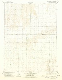
1978 Map of St. Francis 3 SW
USGS Topo · Published 1978About this map
Neville Ch stands as a lonely landmark in this high plains landscape on the border of Cheyenne and Sherman counties during the late 1970s. The terrain is defined by the ephemeral drainages of Little Beaver Creek and Battle Creek, which carve subtle valleys across the townships of Benkelman, Grant, and Jaqua. This survey captures the rural character of western Kansas at a time when industrial activity was largely limited to scattered wells and a small Quarry in the northwest. The map’s reliance on 1974 photogrammetric methods highlights a transition to modern cartographic precision while documenting the persistent section-line road network that dictates the area's geometry. For those researching the geography of the Kansas-Colorado borderlands, this record provides an exact placement of local structures and rural property boundaries.
Find a feature on this map
9 named features on this map. Tap any name to fly to it.
Don’t see what you’re looking for? This feature index may not catch every label — zoom into the map to look around manually.
Map Details
Editions of this 1978 St. Francis 3 SW Map
3 editions found
Other maps of this area

1950 · Bonny Reservoir
USGS Topo · 1:62,500

1952 · St Francis 3
USGS Topo · 1:62,500

1954 · Limon
USGS Topo · 1:250,000

1954 · Goodland
USGS Topo · 1:250,000

1956 · Goodland
USGS Topo · 1:250,000

1957 · Limon
USGS Topo · 1:250,000

1957 · Goodland
USGS Topo · 1:250,000

1958 · Limon
USGS Topo · 1:250,000

1966 · Ruleton NW
USGS Topo · 1:24,000

1966 · Ruleton NE
USGS Topo · 1:24,000