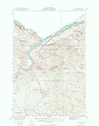
1930 Map of St. Francis
USGS Topo · Published 1974About this map
St John River and the St Francis River form the international boundary with Canada in this northernmost reach of Maine, where the landscape is defined by the timber-driven economy of the 1930s. Small logging outposts and mill sites like Jones Mill and Michaud Mill dot the interior, while remote camps such as Soucier Camp and Jones Camp suggest the seasonal rhythms of the forest industry. Settlement is concentrated primarily along the river valleys, where St Francis and St John serve as the principal hubs connected by the original alignment of Route 161. Education was locally distributed through a network of rural schoolhouses, including Lincoln Sch, McKinley Sch, and Cross Rock Sch. South of the main river corridors, the terrain transitions into a chain of deep-woods waters, notably the Negro Brook Lakes, including First Lake and Second Lake, accessible by primitive routes like the Tote Road.
Find a feature on this map
69 named features on this map. Tap any name to fly to it.
Don’t see what you’re looking for? This feature index may not catch every label — zoom into the map to look around manually.
Map Details
Editions of this 1930 St. Francis Map
5 editions found
Other maps of this area

1928 · Eagle Lake
USGS Topo · 1:48,000

1928 · Winterville
USGS Topo · 1:48,000

1930 · Allagash
USGS Topo · 1:48,000

1930 · St Francis
USGS Topo · 1:48,000

1931 · Fish River Lake
USGS Topo · 1:48,000

1931 · Eagle Lake
USGS Topo · 1:62,500

1931 · Winterville
USGS Topo · 1:62,500

1932 · Fort Kent
USGS Topo · 1:48,000

1932 · Allagash Falls
USGS Topo · 1:48,000

1933 · Allagash
USGS Topo · 1:62,500