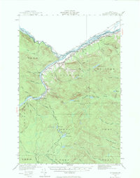
1930 Map of St. Francis
USGS Topo · Published 1974About this map
The St John River and St Francis River define this international borderland, where the northern tip of Maine meets New Brunswick, Canada. In this 1930 survey, the settlement of St Francis serves as a primary hub near the confluence of these major waterways, supported by rural outposts like Back Settlement and industrial sites including Jones Mill. The landscape is etched with the markers of a community integrated with the forest and river, visible in the logging-era legacy of Soucier Camp and Jones Camp, and a network of remote lakes such as the Negro Brook Lakes chain and Glazier Lake. Social infrastructure for the region's families is clearly documented through scattered institutions, notably the McKinley School, Lincoln School, and the St John Church, providing a precise record of early 20th-century habitation patterns along the northern frontier.
Find a feature on this map
72 named features on this map. Tap any name to fly to it.
Don’t see what you’re looking for? This feature index may not catch every label — zoom into the map to look around manually.
Map Details
Editions of this 1930 St. Francis Map
5 editions found
Other maps of this area

1928 · Eagle Lake
USGS Topo · 1:48,000

1928 · Winterville
USGS Topo · 1:48,000

1930 · Allagash
USGS Topo · 1:48,000

1930 · St Francis
USGS Topo · 1:48,000

1931 · Fish River Lake
USGS Topo · 1:48,000

1931 · Eagle Lake
USGS Topo · 1:62,500

1931 · Winterville
USGS Topo · 1:62,500

1932 · Fort Kent
USGS Topo · 1:48,000

1932 · Allagash Falls
USGS Topo · 1:48,000

1933 · Allagash
USGS Topo · 1:62,500