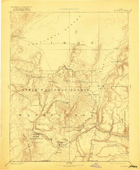
1891 Map of St. George
USGS Topo · Published 1921About this map
Settlements and pioneer outposts anchor this late nineteenth-century reconnaissance of southwestern Utah, centered on the growing community of St. George. The map captures the region before the modern national park system was fully established, noting the early footprint of the Zion National Monument and the extensive Dixie National Forest. The landscape is characterized by its distinct geologic transitions, from the Escalante Desert in the north to the formidable Hurricane Cliff and the Beaver Dam Mountains in the south. Several mining-era locations and small agricultural hamlets are documented, including Iron City, Silver Reef, and Heberville. The presence of the Shebit Indian Reservation along Santa Clara Creek reflects the complex social and territorial layout of Washington County during this reprint of the 1891 survey. High elevations like the Pine Valley Mountains and Hawkins Peak provide a topographical frame for the river-fed valleys where towns like Cedar City and Virgin City were first established.
Find a feature on this map
51 named features on this map. Tap any name to fly to it.
Don’t see what you’re looking for? This feature index may not catch every label — zoom into the map to look around manually.
Map Details
Editions of this 1891 St. George Map
4 editions found
Other maps of this area

1885 · St. George
USGS Topo · 1:250,000

1885 · Beaver
USGS Topo · 1:250,000

1885 · Pioche
USGS Topo · 1:250,000

1886 · Kanab
USGS Topo · 1:250,000

1886 · Saint Thomas
USGS Topo · 1:250,000

1886 · Mt. Trumbull
USGS Topo · 1:250,000

1886 · Pioche
USGS Topo · 1:250,000

1886 · Kaibab
USGS Topo · 1:250,000

1891 · St. George
USGS Topo · 1:250,000

1892 · Mt. Trumbull
USGS Topo · 1:250,000