1967 Map of St Leo
USGS Topo · Published 1968About this map
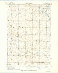
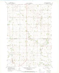
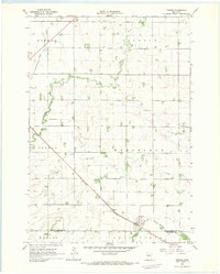
St Leo serves as the central hub of this mid-1960s agricultural landscape, situated at the junction of several civil townships including Oshkosh, Omro, and Burton. The map reflects a region defined by its water management and conservation efforts, evidenced by the Lanners State Wildlife Management Area and the channelized County Ditch No 25. These features, alongside Lanners Lake and Congers Marsh, illustrate the post-war emphasis on balancing productive farmland with wildlife preservation. For genealogists, the map provides precise locations for the St Leo Cem and Burton Cem, which remain as fixed markers of the community's early settlement history. The terrain is further characterized by the meandering courses of Spring Creek and Mud Creek, which cut through the various sections of Yellow Medicine Co and Lyon Co.
Find a feature on this map
21 named features on this map. Tap any name to fly to it.
Don’t see what you’re looking for? This feature index may not catch every label — zoom into the map to look around manually.
Map Details
Editions of this 1967 St Leo Map
This is the sole edition of this map. No revisions or reprints were ever made.
Other maps of this area

1953 · Watertown
USGS Topo · 1:250,000

1953 · New Ulm
USGS Topo · 1:250,000

1957 · New Ulm
USGS Topo · 1:250,000

1958 · New Ulm
USGS Topo · 1:250,000

1958 · Watertown
USGS Topo · 1:250,000

1965 · Boyd
USGS Topo · 1:24,000

1967 · New Ulm
USGS Topo · 1:250,000
1967 · Dawson SW
USGS Topo · 1:24,000

1967 · Minneota
USGS Topo · 1:24,000
1967 · Porter
USGS Topo · 1:24,000