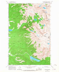
1965 Map of St Marys Lake
USGS Topo · Published 1968About this map
St Marys Lake and the high ridges of the Mission Range dominate this mid-1960s survey of the Flathead Indian Reservation border. The landscape is defined by dramatic elevation changes, where high-altitude features like Lucifer Lake and Lake of the Stars feed steep watercourses. Significant water management infrastructure is evident in the lower elevations, including the Dry Creek Aqueduct and Dry Creek Canal, which transition from the steep mountain runoff to the valley floor. High peaks such as West St Marys Peak and Kakashe Mountain frame glacial features like Fissure Glacier and Sunrise Glacier along the Garden Wall. Notable landmarks for local navigation and history include Elizabeth Falls, Mission Falls, and the Mission Reservoir, alongside several named passes such as Lone Tree Pass and Vacation Pass that mark the Divide between Lake and Missoula counties.
Find a feature on this map
49 named features on this map. Tap any name to fly to it.
Don’t see what you’re looking for? This feature index may not catch every label — zoom into the map to look around manually.
Map Details
Editions of this 1965 St Marys Lake Map
This is the sole edition of this map. No revisions or reprints were ever made.
Other maps of this area

1921 · Elbow Lake
USGS Topo · 1:125,000

1955 · Choteau
USGS Topo · 1:250,000

1956 · Wallace
USGS Topo · 1:250,000

1957 · Choteau
USGS Topo · 1:250,000

1958 · Choteau
USGS Topo · 1:250,000

1959 · Arlee
USGS Topo · 1:62,500

1960 · Wallace
USGS Topo · 1:250,000

1962 · Choteau
USGS Topo · 1:250,000

1964 · Fort Connah
USGS Topo · 1:24,000

1964 · Saint Ignatius
USGS Topo · 1:24,000