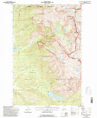
1994 Map of St Marys Lake
USGS Topo · Published 1996About this map
The Mission Mountains Wilderness dominates this landscape, where the high crest of The Garden Wall marks the boundary between the Flathead National Forest and the Flathead Indian Reservation. This high-altitude terrain is defined by glacial activity and alpine hydrology, featuring the Mountaineer Glacier, Fissure Glacier, and Sunset Glacier. These glaciers feed a complex network of high-country basins, including Lucifer Lake and the aptly named Lake of the Clouds.
Find a feature on this map
51 named features on this map. Tap any name to fly to it.
Don’t see what you’re looking for? This feature index may not catch every label — zoom into the map to look around manually.
Map Details
Editions of this 1994 St Marys Lake Map
This is the sole edition of this map. No revisions or reprints were ever made.
Other maps of this area

1921 · Elbow Lake
USGS Topo · 1:125,000

1955 · Choteau
USGS Topo · 1:250,000

1956 · Wallace
USGS Topo · 1:250,000

1957 · Choteau
USGS Topo · 1:250,000

1958 · Choteau
USGS Topo · 1:250,000

1959 · Arlee
USGS Topo · 1:62,500

1960 · Wallace
USGS Topo · 1:250,000

1962 · Choteau
USGS Topo · 1:250,000

1964 · Fort Connah
USGS Topo · 1:24,000

1964 · Saint Ignatius
USGS Topo · 1:24,000