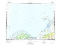
1952 Map of St Michael
USGS Topo · Published 1959About this map
The delta of the Yukon River and the coastal reaches of Norton Sound define this 1952 topographic survey, a period when transportation in western Alaska relied heavily on intricate water routes and seasonal trails. The map documents the northern distributaries of the Yukon, including Kwikpak Pass and the Apoon Pass, which served as vital corridors for the settlements of Kotlik and Kothlik. Further north along the coast, the volcanic geography is evident at St Michael Island and Stuart Island, where the established trading and transit hub of St Michael is situated near the distinctive Crater Mtn.
Find a feature on this map
59 named features on this map. Tap any name to fly to it.
Don’t see what you’re looking for? This feature index may not catch every label — zoom into the map to look around manually.
Map Details
Editions of this 1952 St Michael Map
4 editions found

Other maps of this area

1948 · Norton Bay
USGS Topo · 1:250,000

1950 · Nome
USGS Topo · 1:250,000

1950 · Solomon
USGS Topo · 1:250,000

1951 · Unalakleet
USGS Topo · 1:250,000

1951 · Nome
USGS Topo · 1:250,000

1951 · Solomon
USGS Topo · 1:250,000

1951 · Black
USGS Topo · 1:250,000

1951 · Norton Bay
USGS Topo · 1:250,000

1951 · St Michael
USGS Topo · 1:250,000

1951 · Holy Cross
USGS Topo · 1:250,000