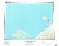
1952 Map of St Michael
USGS Topo · Published 1981About this map
Norton Sound and the intricate coastal wetlands of the Yukon-Kuskokwim Delta dominate this mid-century survey of the St Michael region. The map captures a landscape defined by an enormous network of seasonal waterways, including the Kwikpak Pass, Apoon Pass, and Okwega Pass, which served as vital corridors for the coastal and riverine communities. At the northeastern edge, Stuart Island and the larger St Michael Island provide a stark contrast to the low-lying tundra, with prominent landmarks such as St Michael Mtn and Crater Mtn rising above the surrounding flats. Settlements such as Stebbins, Chaniliut, and Kotlik are positioned strategically along the coast and river mouths, reflecting a traditional reliance on the sea and the delta's salmon-rich waters. A lone Landing Strip near the town of St. Michael signals the evolving transportation needs of this remote coastal hub during the early 1950s.
Find a feature on this map
64 named features on this map. Tap any name to fly to it.
Don’t see what you’re looking for? This feature index may not catch every label — zoom into the map to look around manually.
Map Details
Editions of this 1952 St Michael Map
4 editions found

Other maps of this area

1948 · Norton Bay
USGS Topo · 1:250,000

1950 · Nome
USGS Topo · 1:250,000

1950 · Solomon
USGS Topo · 1:250,000

1951 · Unalakleet
USGS Topo · 1:250,000

1951 · Nome
USGS Topo · 1:250,000

1951 · Solomon
USGS Topo · 1:250,000

1951 · Black
USGS Topo · 1:250,000

1951 · Norton Bay
USGS Topo · 1:250,000

1951 · St Michael
USGS Topo · 1:250,000

1951 · Holy Cross
USGS Topo · 1:250,000