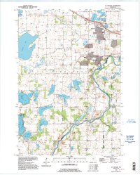
1991 Map of St Michael
USGS Topo · Published 1995About this map
The Crow River winds through this central Minnesota landscape, serving as a natural boundary between Wright County and Hennepin County. Based on 1991 imagery, the map documents the growth of St Michael and Albertville, showing the residential expansion and infrastructure like the Sewage Disposal and Radio Towers that characterize the area's development during this era.
Find a feature on this map
39 named features on this map. Tap any name to fly to it.
Don’t see what you’re looking for? This feature index may not catch every label — zoom into the map to look around manually.
Map Details
Editions of this 1991 St Michael Map
This is the sole edition of this map. No revisions or reprints were ever made.
Other maps of this area

1909 · Rockford
USGS Topo · 1:62,500

1953 · Stillwater
USGS Topo · 1:250,000

1955 · Stillwater
USGS Topo · 1:250,000

1958 · Stillwater
USGS Topo · 1:250,000

1958 · Rockford
USGS Topo · 1:62,500

1958 · Buffalo
USGS Topo · 1:62,500

1961 · Big Lake
USGS Topo · 1:24,000

1961 · Elk River
USGS Topo · 1:24,000

1961 · Monticello
USGS Topo · 1:24,000

1961 · Monticello
USGS Topo · 1:62,500