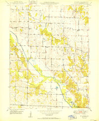
1950 Map of St. Patrick
USGS Topo · Published 1950About this map
St Patrick serves as a central point in this rural landscape, situated just north of the Clark and Lewis County line. The terrain is defined by the winding course of the Wyaconda River and its Old Channel, which carve through the countryside alongside the Little Wyaconda River. This mid-century survey documents a dense network of local institutions that supported the farming community, including an unusually high number of small rural schools such as the Pride of the West School, Diamond School, and Gem School. Family-named landmarks and small burial grounds like Mitts Cemetery and Sisson Cemetery are scattered throughout the township of Jackson, providing a detailed record of the families established here before the further consolidation of rural districts and the loss of many of these one-room schoolhouses.
Find a feature on this map
25 named features on this map. Tap any name to fly to it.
Don’t see what you’re looking for? This feature index may not catch every label — zoom into the map to look around manually.
Map Details
Editions of this 1950 St. Patrick Map
2 editions found
Other maps of this area

1903 · Kahoka
USGS Topo · 1:125,000

1949 · Wayland
USGS Topo · 1:24,000

1949 · Kahoka SE
USGS Topo · 1:24,000

1949 · Kahoka
USGS Topo · 1:24,000

1949 · St. Patrick
USGS Topo · 1:24,000

1950 · Kahoka
USGS Topo · 1:24,000

1950 · Saint Patrick
USGS Topo · 1:24,000

1950 · Kahoka SE
USGS Topo · 1:24,000

1950 · Wayland
USGS Topo · 1:24,000

1950 · Neeper
USGS Topo · 1:24,000