1921 Map of St. Petersburg
USGS Topo · Published 1943About this map
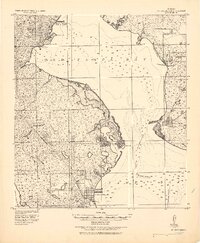
St. Petersburg and its surrounding peninsula are documented here during a period of significant early development along the Florida Gulf Coast. The landscape is defined by the intricate relationship between land and water, featuring the extensive Old Tampa Bay shoreline and the complex drainage of Papy's Bayou and Cross Bayou. Early settlements such as Pinellas Park, Lellman, and Green Springs or Safety Harbor are visible alongside specialized infrastructure like the 24.4 Ft. Dredged Channel serving Port Tampa. The map reveals a transition from natural features like Alligator Swamp and thick Mangrove stands to the emerging urban grid of the city. Notable for local history is the presence of the Brick Road and the various landings and points, such as Coopers Pt and Rocky Pt., which anchored early maritime and overland transport in the region.
Find a feature on this map
36 named features on this map. Tap any name to fly to it.
Don’t see what you’re looking for? This feature index may not catch every label — zoom into the map to look around manually.
Map Details
Editions of this 1921 St. Petersburg Map
2 editions found

Historical Maps of Tampa Through Time
1 maps found