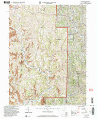
2002 Map of Stafford
USGS Topo · Published 2006About this map
Stafford and Harriettsville anchor this corner of southeast Ohio, where the drainage of the Middle Fork Duck Creek has carved a landscape defined by sharp ridges and deep runs. Much of the eastern terrain falls within the Wayne National Forest, while the western half shows the marks of industry with numerous strip mines and gas wells scattered across the hills. This 2002 revision reflects a rural community deeply connected to its land through a network of small country churches and cemeteries.
Find a feature on this map
28 named features on this map. Tap any name to fly to it.
Don’t see what you’re looking for? This feature index may not catch every label — zoom into the map to look around manually.
Map Details
Editions of this 2002 Stafford Map
This is the sole edition of this map. No revisions or reprints were ever made.
Other maps of this area

1903 · Macksburg
USGS Topo · 1:62,500

1905 · New Matamoras
USGS Topo · 1:62,500

1905 · Woodsfield
USGS Topo · 1:62,500

1905 · Macksburg
USGS Topo · 1:62,500

1909 · Summerfield
USGS Topo · 1:62,500

1911 · Summerfield
USGS Topo · 1:62,500

1924 · New Matamoras
USGS Topo · 1:62,500

1926 · New Matamoras
USGS Topo · 1:62,500

1949 · Clarksburg
USGS Topo · 1:250,000

1956 · Clarksburg
USGS Topo · 1:250,000