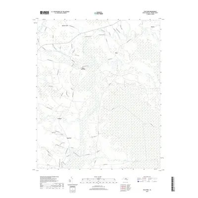
2019 Map of Stag Park
USGS Topo · Published 2019About this map
The Northeast Cape Fear River dominates this Pender County landscape, winding through a complex network of wetlands and creek systems including Burgaw Creek and Holly Shelter Creek. This 2019 survey captures the rural character of the region, where historical settlements like White Stocking and Shelter Neck persist alongside newer infrastructure. The layout of the land is defined by large tracts of undeveloped terrain interspersed with pockets of habitation such as Walkers and Plear. A notable aviation hub, the Stag Air Park, is situated near the Stag Park community, reflecting the area's modern land use. Local history is etched into the road names, with routes like Old Blakes Bridge Rd and Old Maple Hill Rd tracing the paths of earlier transit networks through the river lowlands. This map provides a clear record of the area's hydrology and contemporary settlement patterns.
Find a feature on this map
61 named features on this map. Tap any name to fly to it.
Don’t see what you’re looking for? This feature index may not catch every label — zoom into the map to look around manually.
Map Details
Editions of this 2019 Stag Park Map
This is the sole edition of this map. No revisions or reprints were ever made.
Other maps of this area

1942 · Topsail
USGS Topo · 1:62,500

1942 · Burgaw
USGS Topo · 1:62,500

1947 · Rocky Point
USGS Topo · 1:62,500

1948 · Maple Hill
USGS Topo · 1:62,500

1948 · Topsail
USGS Topo · 1:62,500

1953 · Beaufort
USGS Topo · 1:250,000

1954 · Beaufort
USGS Topo · 1:250,000

1970 · Topsail
USGS Topo · 1:24,000
1970 · Mooretown
USGS Topo · 1:24,000
1970 · Rocky Point
USGS Topo · 1:24,000