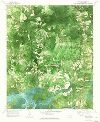
1970 Map of Rocky Point
USGS Topo · Published 1973About this map
The Northeast Cape Fear River dominates the southern reaches of this 1970 orthophotomap, where the Pender Co New Hanover Co line meets the water. This unique hybrid map, created from 1969 aerial photography, provides a literal view of the dense North Carolina coastal plain vegetation and agricultural clearings surrounding Rocky Point. The transportation network of the era is clearly defined by the Seaboard Coast Line railroad and a small Landing Strip nestled between the creeks.
Find a feature on this map
31 named features on this map. Tap any name to fly to it.
Don’t see what you’re looking for? This feature index may not catch every label — zoom into the map to look around manually.
Map Details
Editions of this 1970 Rocky Point Map
2 editions found
Other maps of this area

1942 · Burgaw
USGS Topo · 1:62,500

1947 · Rocky Point
USGS Topo · 1:62,500

1953 · Florence
USGS Topo · 1:250,000

1953 · Beaufort
USGS Topo · 1:250,000

1954 · Florence
USGS Topo · 1:250,000

1954 · Beaufort
USGS Topo · 1:250,000

1954 · Acme
USGS Topo · 1:62,500

1955 · Atkinson
USGS Topo · 1:62,500

1970 · Scotts Hill
USGS Topo · 1:24,000
1970 · Castle Hayne
USGS Topo · 1:24,000