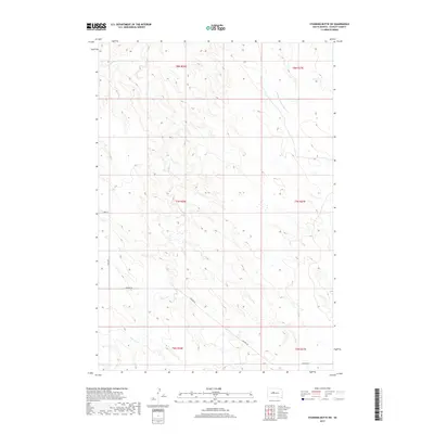
2017 Map of Standing Butte SW
USGS Topo · Published 2017About this map
Sansarc Creek and its northern branch, N Fork Sansarc Creek, define the topography of this section of Stanley County. The land is characterized by a network of drainage basins and coulees, including the headwaters of the W Fork Minneconjou Creek in the northeastern quadrant. Modern infrastructure is represented by a sparse grid of section-line roads, notably Sansarc Road and 256th Avenue, which navigate the rises and falls of the prairie. This 2017 U.S. Geological Survey representation documents the contemporary state of the landscape, where cattle ranching and large-scale agriculture are facilitated by these foundational routes. The map provides a clear record of the hydrography and public land survey system divisions across townships t7n r26e and t8n r26e, tracing the exact path of the seasonal waterways that shaped local settlement patterns.
Find a feature on this map
12 named features on this map. Tap any name to fly to it.
Don’t see what you’re looking for? This feature index may not catch every label — zoom into the map to look around manually.
Map Details
Editions of this 2017 Standing Butte SW Map
This is the sole edition of this map. No revisions or reprints were ever made.
Other maps of this area

1954 · Pierre
USGS Topo · 1:250,000

1956 · Sansarc NE
USGS Topo · 1:24,000

1956 · Crockett Mountains
USGS Topo · 1:24,000

1958 · Pierre
USGS Topo · 1:250,000

1980 · Princes Ranch
USGS Topo · 1:25,000

1982 · Sansarc
USGS Topo · 1:24,000

1982 · Mission Ridge
USGS Topo · 1:24,000

1983 · Hayes North
USGS Topo · 1:24,000

1983 · Standing Butte
USGS Topo · 1:24,000
1983 · Standing Butte SW
USGS Topo · 1:24,000