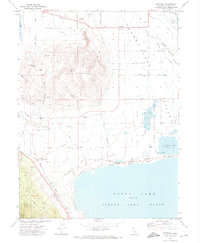
1972 Map of Standish
USGS Topo · Published 1974About this map
Honey Lake dominates the southern portion of this landscape, its shoreline meeting the northern reaches of the Sierra Army Depot. The terrain is characterized by the stark contrast between the desert flats of the Lassen Valley and the sudden rise of Bald Mountain, which reaches over 5,000 feet. Local ranching and irrigation history is etched into the grid of private lanes such as Shrode Lane and Cappazolli Lane, alongside an extensive network of water features including Tanner Slough and the Deep Cut. The small settlement of Standish serves as a northern anchor, while Buntingville sits at the base of the western hills. The presence of the Honey Lake Wildlife Area and Hartson Lake indicates the area's ecological importance, even as the landscape was shaped by utility and military use during the early 1970s.
Find a feature on this map
48 named features on this map. Tap any name to fly to it.
Don’t see what you’re looking for? This feature index may not catch every label — zoom into the map to look around manually.
Map Details
Editions of this 1972 Standish Map
This is the sole edition of this map. No revisions or reprints were ever made.
Other maps of this area

1886 · Honey Lake
USGS Topo · 1:250,000

1891 · Honey Lake
USGS Topo · 1:250,000

1893 · Honey Lake
USGS Topo · 1:250,000

1950 · Kettle Rock
USGS Topo · 1:62,500

1950 · Milford
USGS Topo · 1:62,500

1954 · Susanville
USGS Topo · 1:62,500

1954 · Litchfield
USGS Topo · 1:62,500

1955 · Westwood
USGS Topo · 1:250,000

1958 · Westwood
USGS Topo · 1:250,000

1959 · Westwood
USGS Topo · 1:250,000