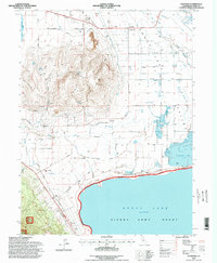
1994 Map of Standish
USGS Topo · Published 1998About this map
Bald Mountain dominates the western interior of this high-desert landscape, rising sharply above the complex hydrology of Honey Lake Valley. The eastern half of the sheet is defined by the terminal waters of Honey Lake and the Honey Lake Wildlife Area, where numerous sloughs like Fish Slough and Tanner Slough feed into a network of managed water systems, including the Lower Canal and the historic Eagle Lake Ditch. Settlement centers on the small communities of Standish and Buntingville, the latter located near Lake Sch and a local Cem. The southern portion of the map transitions into the Sierra Army Depot, which sits along the northern shoreline of the lake. This 1990s revision details an era of significant land management, where irrigation infrastructure like the Standish Ditch and the Main Canal supported agricultural life between the peaks of Bass Hill and the seasonal wetlands.
Find a feature on this map
57 named features on this map. Tap any name to fly to it.
Don’t see what you’re looking for? This feature index may not catch every label — zoom into the map to look around manually.
Map Details
Editions of this 1994 Standish Map
This is the sole edition of this map. No revisions or reprints were ever made.
Other maps of this area

1886 · Honey Lake
USGS Topo · 1:250,000

1891 · Honey Lake
USGS Topo · 1:250,000

1893 · Honey Lake
USGS Topo · 1:250,000

1950 · Kettle Rock
USGS Topo · 1:62,500

1950 · Milford
USGS Topo · 1:62,500

1954 · Susanville
USGS Topo · 1:62,500

1954 · Litchfield
USGS Topo · 1:62,500

1955 · Westwood
USGS Topo · 1:250,000

1958 · Westwood
USGS Topo · 1:250,000

1959 · Westwood
USGS Topo · 1:250,000