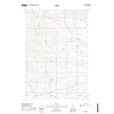
2020 Map of Stanford
USGS Topo · Published 2020About this map
The Palouse Range rises over a landscape defined by rolling agricultural plateaus and deeply cut creek drainages in this 2020 Latah County survey. The settlement of Stanford sits near the intersection of Stanford Rd and Anderson Rd, serving as a central point for the surrounding rural homesteads. The topography is intricately carved by the Middle Fork Big Bear Cr and the W Fork Big Bear Cr, which dictate the winding paths of local thoroughfares like White Pine Flats Rd. A unique aviation landmark, the Friendly Persuasion Farm Airport, is located south of Stanford Point, highlighting the integration of private air infrastructure within the region's farming economy. From the elevations of Little Bear Ridge to the lowlands along Dry Cr, the map illustrates a modern rural Idaho landscape where land use is dictated by the rugged contours of the Dry Ridge.
Find a feature on this map
45 named features on this map. Tap any name to fly to it.
Don’t see what you’re looking for? This feature index may not catch every label — zoom into the map to look around manually.
Map Details
Editions of this 2020 Stanford Map
This is the sole edition of this map. No revisions or reprints were ever made.
Other maps of this area

1955 · Pullman
USGS Topo · 1:250,000

1958 · Pullman
USGS Topo · 1:250,000

1960 · Troy
USGS Topo · 1:24,000

1960 · Moscow Mtn
USGS Topo · 1:24,000

1960 · Potlatch
USGS Topo · 1:62,500

1961 · Deary
USGS Topo · 1:62,500

1961 · Kendrick
USGS Topo · 1:62,500

1961 · Moscow
USGS Topo · 1:62,500

1981 · Potlatch
USGS Topo · 1:100,000
1990 · Stanford
USGS Topo · 1:24,000