
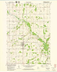
1978 Map of Stangelville
USGS Topo · Published 1979About this map
Stangelville and the surrounding rural townships of Montpelier, West Kewaunee, Franklin, and Carlton anchor this landscape of family farms and glacial terrain. The map captures the agricultural heart of Kewaunee County, where high ground like the Montpelier Hills and Cherneyville Hill drops into the drainage basins of the Twin River, Scarboro Creek, and Black Creek. Small hamlets and rural crossroads centers serve the farming community, marked by landmarks such as the St Paul Sch & Ch, the Townhall near Ellisville, and the St Wenceslaus Ch in Pilsen. A dense network of local roads, many bearing family names like Gasche Road, Stodola Road, and Beckelberg Road, connects these dispersed settlements. To the east, the Little Scarboro State Public Hunting Grounds and Lipsky Swamp indicate a shift toward more wooded, low-lying wetlands preserved for public use.
Find a feature on this map
53 named features on this map. Tap any name to fly to it.
Don’t see what you’re looking for? This feature index may not catch every label — zoom into the map to look around manually.
Map Details
Editions of this 1978 Stangelville Map
This is the sole edition of this map. No revisions or reprints were ever made.
Other maps of this area

1952 · Casco
USGS Topo · 1:62,500

1954 · Kewaunee
USGS Topo · 1:62,500

1954 · Denmark
USGS Topo · 1:62,500

1954 · New Franken
USGS Topo · 1:62,500

1954 · Manitowoc
USGS Topo · 1:250,000

1958 · Manitowoc
USGS Topo · 1:250,000

1978 · Casco
USGS Topo · 1:24,000

1978 · Denmark
USGS Topo · 1:24,000

1978 · Poland
USGS Topo · 1:24,000
1978 · Luxemburg
USGS Topo · 1:24,000