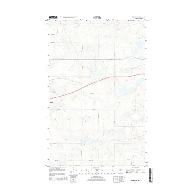
2014 Map of Stanley SE
USGS Topo · Published 2014About this map
Stanley occupies the western edge of this prairie landscape, where the town's expansion meets the rural grid of Mountrail County. The terrain is defined by the winding course of the Little Knife River, which cuts across the central portion of the sheet. This 2014 survey documents the transportation infrastructure of the era, showing the primary artery of Old Highway 2 running east-to-west across the northern half of the quadrangle. The surrounding township is organized by a dense network of section-line roads, including Clearlake Rd and various numbered avenues and streets that facilitate the region's agricultural activity. The map provides a detailed view of the local drainage patterns and the many small depressions and wetlands characteristic of this North Dakota glacial landscape.
Find a feature on this map
19 named features on this map. Tap any name to fly to it.
Don’t see what you’re looking for? This feature index may not catch every label — zoom into the map to look around manually.
Map Details
Editions of this 2014 Stanley SE Map
This is the sole edition of this map. No revisions or reprints were ever made.
Other maps of this area

1953 · Williston
USGS Topo · 1:250,000

1957 · Williston
USGS Topo · 1:250,000

1969 · Stanley
USGS Topo · 1:24,000

1969 · Stanley SE
USGS Topo · 1:24,000

1981 · Stanley SE
USGS Topo · 1:24,000

1981 · Lostwood
USGS Topo · 1:24,000

1981 · Palermo
USGS Topo · 1:24,000
1981 · Palermo NW
USGS Topo · 1:24,000
1981 · Epworth NW
USGS Topo · 1:24,000
1981 · Sikes Dam
USGS Topo · 1:24,000