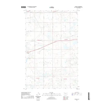
2020 Map of Stanley SE
USGS Topo · Published 2020About this map
Stanley anchors the western edge of this prairie landscape, where the Missouri Plateau begins to yield to the drainage of the Little Knife River. This 2020 survey illustrates the transition from the city’s historic core toward newer developments like Country Ests, set against a backdrop of deep-rooted agricultural section lines. The transport network reveals layers of regional history, with Old Hwy 2 and Co Rd 22 cutting across the glacial topography, while newer routes like Prairie Trl and Clear Lake Rd connect the scattered wetlands and prairie potholes that define the rural surroundings of Mountrail County.
Find a feature on this map
29 named features on this map. Tap any name to fly to it.
Don’t see what you’re looking for? This feature index may not catch every label — zoom into the map to look around manually.
Map Details
Editions of this 2020 Stanley SE Map
This is the sole edition of this map. No revisions or reprints were ever made.
Other maps of this area

1953 · Williston
USGS Topo · 1:250,000

1957 · Williston
USGS Topo · 1:250,000

1969 · Stanley
USGS Topo · 1:24,000

1969 · Stanley SE
USGS Topo · 1:24,000

1981 · Stanley SE
USGS Topo · 1:24,000

1981 · Lostwood
USGS Topo · 1:24,000

1981 · Palermo
USGS Topo · 1:24,000
1981 · Palermo NW
USGS Topo · 1:24,000
1981 · Epworth NW
USGS Topo · 1:24,000
1981 · Sikes Dam
USGS Topo · 1:24,000