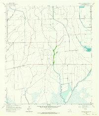
1962 Map of Stanolind Reservoir
USGS Topo · Published 1964About this map
The coastal prairie of Chambers County is defined here by the intricate coordination of water and petroleum extraction in the early 1960s. Extensive irrigation networks, including the Lone Star Canal, Devers Main Canal, and Devers East Canal, cut through the landscape to support local agriculture. The central focus is the Stanolind Reservoir, which serves as a critical water source for the surrounding fields and industry.
Find a feature on this map
16 named features on this map. Tap any name to fly to it.
Don’t see what you’re looking for? This feature index may not catch every label — zoom into the map to look around manually.
Map Details
Editions of this 1962 Stanolind Reservoir Map
Other maps of this area

1931 · High Island
USGS Topo · 1:24,000

1931 · Frozen Point
USGS Topo · 1:24,000

1933 · Frozen Point
USGS Topo · 1:31,680

1943 · High Island
USGS Topo · 1:31,680

1943 · Frozen Point
USGS Topo · 1:24,000

1943 · Sea Breeze
USGS Topo · 1:24,000

1943 · Stowell
USGS Topo · 1:24,000

1945 · Sea Breeze
USGS Topo · 1:31,680

1950 · Houston
USGS Topo · 1:250,000

1956 · Houston
USGS Topo · 1:250,000