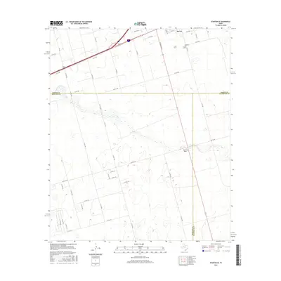
2016 Map of Stanton SE
USGS Topo · Published 2016About this map
Stanton anchors the northern edge of this West Texas landscape, where the southern boundary of Martin County meets Midland and Glasscock Counties. The terrain is defined by the broad, meandering path of Mustang Draw, which cuts a wide channel across the central portion of the map. This arid drainage basin influenced the regional road network, as routes like Ranch RD 307 and numerous county roads navigate around its course. To the north, Evergreen Cem serves as a significant marker for genealogical research near the settlement of Stanton. The map captures a moment in the 21st century where the intersection of interstate infrastructure and traditional ranching life is visible, particularly around the community of Dix and the well-ordered grid of local roads like Fm 829 and Co RD 2100.
Find a feature on this map
45 named features on this map. Tap any name to fly to it.
Don’t see what you’re looking for? This feature index may not catch every label — zoom into the map to look around manually.
Map Details
Editions of this 2016 Stanton SE Map
This is the sole edition of this map. No revisions or reprints were ever made.
Other maps of this area

1941 · Morita
USGS Topo · 1:62,500

1949 · Morita
USGS Topo · 1:62,500

1954 · Big Spring
USGS Topo · 1:250,000

1954 · San Angelo
USGS Topo · 1:250,000

1958 · San Angelo
USGS Topo · 1:250,000

1958 · Big Spring
USGS Topo · 1:250,000

1965 · San Angelo
USGS Topo · 1:250,000

1965 · Dewey Lake
USGS Topo · 1:24,000

1965 · Spraberry
USGS Topo · 1:24,000
1965 · Stephenson Lake
USGS Topo · 1:24,000