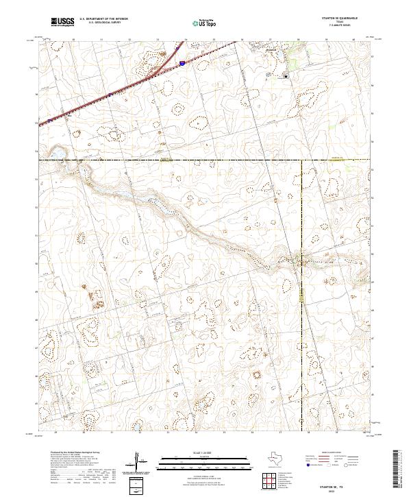
2022 Map of Stanton SE
USGS Topo · Published 2022About this map
The West Texas plains at the junction of Martin, Midland, and Glasscock counties reveal a landscape defined by industrial transport and the ancient course of Mustang Draw. In the northern portion of the map, Stanton sits along the busy corridor of Interstate 20, while the settlement of Dix serves as a marker for the railway and highway transition further west. This 2022 survey captures the area's rural character, where the grid of county roads—such as Co RD 2100 and S Co RD 1040—intersects with the sweeping path of the draw. Genealogists and local historians will find the Evergreen Cem on the eastern edge of Stanton, providing a key point of reference for family research in this part of the Permian Basin. The region's connection to cattle and oil is evident in the network of ranch roads like Ranch Rd 307 and Farm Rd 307 that traverse the open terrain.
Find a feature on this map
52 named features on this map. Tap any name to fly to it.
Don’t see what you’re looking for? This feature index may not catch every label — zoom into the map to look around manually.
Map Details
Editions of this 2022 Stanton SE Map
This is the sole edition of this map. No revisions or reprints were ever made.
Other maps of this area

1941 · Morita
USGS Topo · 1:62,500

1949 · Morita
USGS Topo · 1:62,500

1954 · Big Spring
USGS Topo · 1:250,000

1954 · San Angelo
USGS Topo · 1:250,000

1958 · San Angelo
USGS Topo · 1:250,000

1958 · Big Spring
USGS Topo · 1:250,000

1965 · San Angelo
USGS Topo · 1:250,000

1965 · Dewey Lake
USGS Topo · 1:24,000

1965 · Spraberry
USGS Topo · 1:24,000
1965 · Stephenson Lake
USGS Topo · 1:24,000