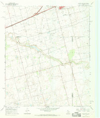
1966 Map of Stanton SE
USGS Topo · Published 1969About this map
Spraberry Trend Oil Field dominates this West Texas landscape, illustrating the intensive petroleum extraction effort of the mid-1960s. The survey reveals a dense network of oil wells, pipelines, and maintenance features like a Pumping Sta and a central Landing Strip. These industrial footprints are superimposed over the natural drainage of Mustang Draw, which snakes across the county lines of Martin, Midland, and Glasscock.
Find a feature on this map
14 named features on this map. Tap any name to fly to it.
Don’t see what you’re looking for? This feature index may not catch every label — zoom into the map to look around manually.
Map Details
Editions of this 1966 Stanton SE Map
This is the sole edition of this map. No revisions or reprints were ever made.
Other maps of this area

1941 · Morita
USGS Topo · 1:62,500

1949 · Morita
USGS Topo · 1:62,500

1954 · Big Spring
USGS Topo · 1:250,000

1954 · San Angelo
USGS Topo · 1:250,000

1958 · San Angelo
USGS Topo · 1:250,000

1958 · Big Spring
USGS Topo · 1:250,000

1965 · San Angelo
USGS Topo · 1:250,000

1965 · Dewey Lake
USGS Topo · 1:24,000

1965 · Spraberry
USGS Topo · 1:24,000
1965 · Stephenson Lake
USGS Topo · 1:24,000