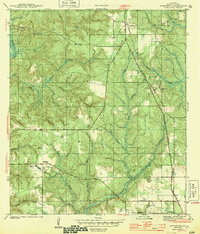
1944 Map of Stapleton
USGS Topo · Published 1944About this map
Stapleton and the Greek-founded colony of Malbis anchor this 1940s landscape in Baldwin County, where the Louisville and Nashville railroad cuts a diagonal line through the piney woods. The settlement at Malbis is particularly well-defined, showing the Malbis Cem and Malbis Fire Tower alongside the historic Spanish Trail. This survey captures the transition from small rural communities to early regional infrastructure, evidenced by the Airway Beacon near D'Olive Creek.
Find a feature on this map
32 named features on this map. Tap any name to fly to it.
Don’t see what you’re looking for? This feature index may not catch every label — zoom into the map to look around manually.
Map Details
Editions of this 1944 Stapleton Map
2 editions found
Other maps of this area

1920 · Robertsdale
USGS Topo · 1:62,500

1921 · Fairhope
USGS Topo · 1:62,500

1939 · Daphne
USGS Topo · 1:31,680

1940 · Silverhill
USGS Topo · 1:31,680

1941 · Daphne
USGS Topo · 1:31,680

1941 · Silverhill
USGS Topo · 1:31,680

1941 · Blakeley
USGS Topo · 1:31,680

1941 · Bay Minette
USGS Topo · 1:62,500

1941 · Robertsdale
USGS Topo · 1:62,500

1941 · Fairhope
USGS Topo · 1:62,500