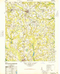
1948 Map of Stapleton
USGS Topo · Published 1948About this map
Wrens and Stapleton serve as central hubs in this Jefferson County landscape, where the Georgia and Florida Railroad and the Savannah and Atlanta Railroad define the local transport economy. The map reveals a post-war rural society deeply rooted in its local institutions, evidenced by the dense concentration of named churches, schools, and family burial grounds such as the Ponder Family Cemetery and Stone Springfield Church and Cemetery.
Find a feature on this map
81 named features on this map. Tap any name to fly to it.
Don’t see what you’re looking for? This feature index may not catch every label — zoom into the map to look around manually.
Map Details
Editions of this 1948 Stapleton Map
2 editions found
Other maps of this area

1919 · Gough
USGS Topo · 1:62,500

1920 · Stapleton
USGS Topo · 1:62,500

1922 · Harlem
USGS Topo · 1:62,500

1922 · Hephzibah
USGS Topo · 1:62,500

1948 · Hephzibah
USGS Topo · 1:62,500

1948 · Harlem
USGS Topo · 1:62,500

1948 · Stapleton
USGS Topo · 1:62,500

1948 · Gough
USGS Topo · 1:62,500

1948 · Blythe
USGS Topo · 1:24,000

1948 · Louisville
USGS Topo · 1:24,000