
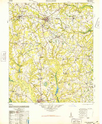
1948 Map of Stapleton
USGS Topo · Published 1948About this map
The agrarian landscape of Jefferson County is defined by a dense network of country churches and family-named landmarks just after the post-war era. Wrens and Stapleton serve as the primary hubs for a region where the Georgia and Florida Railroad and the Savannah and Atlanta Railroad intersect, facilitating the movement of local goods. Numerous mill ponds, including Kings Mill Pond and Stapleton Mill Pond, are scattered across the terrain, suggesting a legacy of local processing along watercourses like Reedy Creek and Rocky Comfort Creek.
Find a feature on this map
96 named features on this map. Tap any name to fly to it.
Don’t see what you’re looking for? This feature index may not catch every label — zoom into the map to look around manually.
Map Details
Editions of this 1948 Stapleton Map
2 editions found
Other maps of this area

1919 · Gough
USGS Topo · 1:62,500

1920 · Stapleton
USGS Topo · 1:62,500

1922 · Harlem
USGS Topo · 1:62,500

1922 · Hephzibah
USGS Topo · 1:62,500

1948 · Hephzibah
USGS Topo · 1:62,500

1948 · Harlem
USGS Topo · 1:62,500

1948 · Gough
USGS Topo · 1:62,500

1948 · Blythe
USGS Topo · 1:24,000

1948 · Louisville
USGS Topo · 1:24,000

1950 · Louisville
USGS Topo · 1:24,000