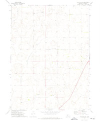
1972 Map of Stapleton SW
USGS Topo · Published 1975About this map
Isolated cattle operations and private aviation facilities define this Lincoln County landscape during the early 1970s. The map highlights the sprawling nature of Nebraska ranching, with large family-run estates such as the Horseshoe Bar Ranch and the Hadley Barrett IX Ranch serving as the primary centers of activity. These named ranches, including Sivits Ranch and Melvin Ranch, reflect a heritage of land ownership where individual properties encompass vast sections of the Sandhills. A lone Landing Strip near the center of the quadrangle suggests the importance of light aircraft for navigating and managing these extensive rangelands. Topographical lines reveal the subtle, undulating terrain typical of the region, where water resources and section lines like the boundary between T. 16 N. and T. 15 N. dictate the layout of roads and homesteads.
Find a feature on this map
7 named features on this map. Tap any name to fly to it.
Don’t see what you’re looking for? This feature index may not catch every label — zoom into the map to look around manually.
Map Details
Editions of this 1972 Stapleton SW Map
This is the sole edition of this map. No revisions or reprints were ever made.
Other maps of this area

1899 · North Platte
USGS Topo · 1:125,000

1902 · North Platte
USGS Topo · 1:125,000

1954 · North Platte
USGS Topo · 1:250,000

1956 · North Platte
USGS Topo · 1:250,000

1957 · North Platte
USGS Topo · 1:250,000

1967 · North Platte
USGS Topo · 1:250,000

1970 · North Platte East
USGS Topo · 1:24,000

1970 · North Platte West
USGS Topo · 1:24,000
1970 · Maxwell NE
USGS Topo · 1:24,000

1972 · Stapleton NW
USGS Topo · 1:24,000