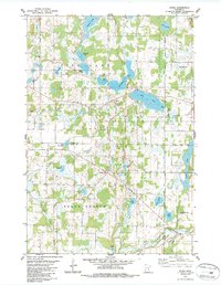
1983 Map of Stark
USGS Topo · Published 1987About this map
Glacial lakes and wetlands dominate this portion of eastern Minnesota, where the settlement of Stark sits at a crossroads near the south shore of Fish Lake. The landscape is a complex network of water bodies, including Mandall Lake, Goose Lake, and Big Pine Lake, many of which are linked by smaller streams or drainage features like Judicial Ditch No 4. This 1983 survey shows the rural character of the region as it transitions between the township of Harris and the northern reaches of North Branch. Local community life is anchored by the Fish Lake Ch and its adjacent Cem, while Fish Lake County Park highlights the area's importance for recreation. To the south, the Sunrise River and Hay Creek wind through the terrain, illustrating the natural drainage patterns that have historically shaped local land use and boundary lines between Chisago and Isanti counties.
Find a feature on this map
36 named features on this map. Tap any name to fly to it.
Don’t see what you’re looking for? This feature index may not catch every label — zoom into the map to look around manually.
Map Details
Editions of this 1983 Stark Map
2 editions found
Other maps of this area

1950 · Rush City
USGS Topo · 1:48,000

1953 · Stillwater
USGS Topo · 1:250,000

1955 · Rush City
USGS Topo · 1:62,500

1955 · Forest Lake
USGS Topo · 1:62,500

1955 · Isanti
USGS Topo · 1:62,500

1955 · Stillwater
USGS Topo · 1:250,000

1958 · Stillwater
USGS Topo · 1:250,000

1961 · Cambridge
USGS Topo · 1:62,500

1965 · Stillwater
USGS Topo · 1:250,000
1974 · Stacy
USGS Topo · 1:24,000