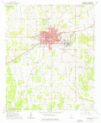
1965 Map of Starkville
USGS Topo · Published 1976About this map
The growing college town of Starkville is captured here in the mid-1960s, anchored by the sprawling campus of Mississippi State University and the downtown Courthouse. This era of development is evident in the residential expansion toward Clayton Village and the presence of institutions like Henderson High Sch and Overstreet Sch. The map reveals a landscape defined by its creek network, including Talking Warrior Creek and Tobacco Juice Creek, which drain the surrounding agricultural and timbered lands.
Find a feature on this map
44 named features on this map. Tap any name to fly to it.
Don’t see what you’re looking for? This feature index may not catch every label — zoom into the map to look around manually.
Map Details
Editions of this 1965 Starkville Map
4 editions found
Other maps of this area

1953 · West Point
USGS Topo · 1:250,000

1958 · West Point
USGS Topo · 1:250,000

1959 · Artesia
USGS Topo · 1:62,500

1959 · West Point
USGS Topo · 1:62,500

1959 · Pheba
USGS Topo · 1:62,500

1963 · West Point
USGS Topo · 1:250,000

1965 · Starkville
USGS Topo · 1:24,000

1965 · Bluff Lake
USGS Topo · 1:24,000

1965 · Longview
USGS Topo · 1:24,000

1965 · Bradley
USGS Topo · 1:24,000