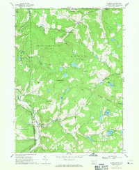
1968 Map of Starrucca
USGS Topo · Published 1971About this map
Starrucca sits at the nexus of the Erie Lackawanna and Delaware and Hudson rail corridors, defining the industrial and transit character of this northern Wayne County landscape. In the late 1960s, the terrain is a mosaic of steep ridges like Shrawder Mountain and high-plateau agriculture, marked by numerous small settlements such as Gardinier Corners and Finnegan Corners. The presence of several quarries and gravel pits suggests active resource extraction, while the Landing Strip near Maple Hill indicates modern infrastructure reaching these traditional rural corners.
Find a feature on this map
54 named features on this map. Tap any name to fly to it.
Don’t see what you’re looking for? This feature index may not catch every label — zoom into the map to look around manually.
Map Details
Editions of this 1968 Starrucca Map
3 editions found
Other maps of this area

1905 · Nineveh
USGS Topo · 1:62,500

1924 · Starrucca
USGS Topo · 1:48,000

1924 · Deposit
USGS Topo · 1:62,500

1926 · Deposit
USGS Topo · 1:62,500

1926 · Starrucca
USGS Topo · 1:62,500

1930 · Starrucca
USGS Topo · 1:48,000

1932 · Susquehanna
USGS Topo · 1:62,500

1933 · Starrucca
USGS Topo · 1:62,500

1935 · Susquehanna
USGS Topo · 1:62,500

1943 · Honesdale
USGS Topo · 1:125,000