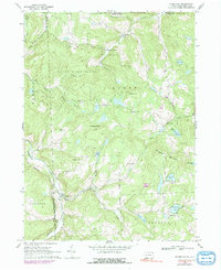
1968 Map of Starrucca
USGS Topo · Published 1991About this map
Starrucca sits at the southwestern edge of this landscape, where the Delaware and Hudson railroad traces the valley of Starrucca Creek. The area is characterized by high, rounded terrain including Shrawder Mountain and Penn Hill, dotted with numerous named crossroads and remote hamlets. Settlements like Sherman, Scott Center, and Shehawken are connected by a network of rural roads and jeep trails, reflecting a late 20th-century landscape that remains largely undeveloped.
Find a feature on this map
52 named features on this map. Tap any name to fly to it.
Don’t see what you’re looking for? This feature index may not catch every label — zoom into the map to look around manually.
Map Details
Editions of this 1968 Starrucca Map
3 editions found
Other maps of this area

1905 · Nineveh
USGS Topo · 1:62,500

1924 · Starrucca
USGS Topo · 1:48,000

1924 · Deposit
USGS Topo · 1:62,500

1926 · Deposit
USGS Topo · 1:62,500

1926 · Starrucca
USGS Topo · 1:62,500

1930 · Starrucca
USGS Topo · 1:48,000

1932 · Susquehanna
USGS Topo · 1:62,500

1933 · Starrucca
USGS Topo · 1:62,500

1935 · Susquehanna
USGS Topo · 1:62,500

1943 · Honesdale
USGS Topo · 1:125,000