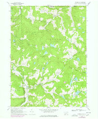
1968 Map of Starrucca
USGS Topo · Published 1978About this map
Starrucca sits at the southern edge of this survey, where the Wayne Co Corporate Boundary meets the winding Starrucca Creek. The landscape is defined by the intersection of small rural communities and extensive natural preserves like State Game Lands No 70 and Broome State Forest. Numerous family-named intersections such as Finnegan Corners, Gardiner Corners, and Farrell Corners trace the historic road network through Scott and Thompson townships.
Find a feature on this map
49 named features on this map. Tap any name to fly to it.
Don’t see what you’re looking for? This feature index may not catch every label — zoom into the map to look around manually.
Map Details
Editions of this 1968 Starrucca Map
3 editions found
Other maps of this area

1905 · Nineveh
USGS Topo · 1:62,500

1924 · Starrucca
USGS Topo · 1:48,000

1924 · Deposit
USGS Topo · 1:62,500

1926 · Deposit
USGS Topo · 1:62,500

1926 · Starrucca
USGS Topo · 1:62,500

1930 · Starrucca
USGS Topo · 1:48,000

1932 · Susquehanna
USGS Topo · 1:62,500

1933 · Starrucca
USGS Topo · 1:62,500

1935 · Susquehanna
USGS Topo · 1:62,500

1943 · Honesdale
USGS Topo · 1:125,000