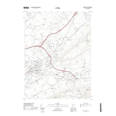
2019 Map of State College
USGS Topo · Published 2019About this map
Pennsylvania State University and the surrounding University Park campus anchor the northern end of this corridor, where the residential and commercial development of State College meets the natural boundaries of the Nittany Valley. The landscape is defined by the sharp rise of Nittany Mtn to the east and Tussey Mountain to the south, containing the suburban expansion into areas like Panorama Village and Harris Acres. Waterways including Spring Creek and Slab Cabin Run carve through the valley floor, passing through older community hubs such as Lemont and Boalsburg. This modern survey illustrates the intensive road network, including the path of I-99 and US-322, which has integrated formerly distinct villages like Houserville and Dalevue into a continuous urbanized area. Notable local landmarks for researchers include several historic burial sites, such as the Boalsburg Cem and Rock Hill Cem, alongside the University Park Airport and the specialized South Hills School of Business and Technology.
Find a feature on this map
67 named features on this map. Tap any name to fly to it.
Don’t see what you’re looking for? This feature index may not catch every label — zoom into the map to look around manually.
Map Details
Editions of this 2019 State College Map
This is the sole edition of this map. No revisions or reprints were ever made.
Other maps of this area

1908 · Bellefonte
USGS Topo · 1:62,500

1909 · Bellefonte
USGS Topo · 1:62,500

1919 · Menno
USGS Topo · 1:62,500

1924 · Centre Hall
USGS Topo · 1:62,500

1924 · Lewistown
USGS Topo · 1:62,500

1927 · Lewisburg
USGS Topo · 1:62,500

1929 · Centre Hall
USGS Topo · 1:62,500

1935 · Allensville
USGS Topo · 1:62,500

1938 · Allensville
USGS Topo · 1:62,500

1943 · Lewistown
USGS Topo · 1:125,000