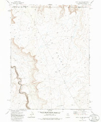
1977 Map of State Line Camp
USGS Topo · Published 1986About this map
State Line Camp sits at the high-desert border where Owyhee County and Idaho and Nevada meet. This 1970s landscape is defined by the deep incision of the South Fork Owyhee River, which snakes through the southwestern portion of the map. The surrounding terrain transitions from the high elevations of Peterson Table to the broad expanse of the Y P Desert. Human infrastructure in this isolated region is sparse, consisting primarily of an east-west Pipeline near the northern boundary and a local Water Tank supporting regional activity. The presence of a Gravel Pit near the river suggests small-scale land use or road maintenance in an otherwise undeveloped high-plateau environment.
Find a feature on this map
9 named features on this map. Tap any name to fly to it.
Don’t see what you’re looking for? This feature index may not catch every label — zoom into the map to look around manually.
Map Details
Editions of this 1977 State Line Camp Map
2 editions found
Other maps of this area

1955 · McDermitt
USGS Topo · 1:250,000

1955 · Jordan Valley
USGS Topo · 1:250,000

1957 · Jordan Valley
USGS Topo · 1:250,000

1958 · Jordan Valley
USGS Topo · 1:250,000

1959 · McDermitt
USGS Topo · 1:250,000

1964 · Hat Peak
USGS Topo · 1:62,500

1971 · Juniper Basin
USGS Topo · 1:24,000

1973 · Bull Camp Butte
USGS Topo · 1:24,000
1973 · Rubber Hill
USGS Topo · 1:24,000

1973 · Twelvemile Flat
USGS Topo · 1:24,000